Tell Leilan, June 2002
Mark Besonen (University of Massachusetts, besonen@geo.umass.edu) and Mauro Cremaschi (Università degli Studi di Milano, mauro.cremaschi@libero.it)
About this Report
This field report was prepared by Besonen and Cremaschi based on a field walking survey carried out within a 15 km radius of Tell Leilan during six days in June 2002.
General Description of Quaternary Stratigraphy and Situation of Tell Leilan
Tell Leilan is located in a broad, undulating alluvial plain (Fig. 1) underlain by a Pleistocene gravel (locally cemented by calcrete), and some plateau basalts. The plain is essentially an alluvial apron shed off of the Tur Abdin (Turkey) located to the north. The plain extends to the south towards the Wadi Radd where it coalesces with a series of smaller alluvial cones being shed off of the Jebel Sinjar (Iraq).
The main body of the alluvial plain is composed primarily of reddish-brown overbank flood deposits and sands
(Fig. 2). Significant pedogenetic development, including the development of a carbonate enriched horizon, was observed at several locations, and suggests a substantial period of exposure for this unit during the Pleistocene. In general, coarser sediments such as channel gravels are found towards the north reflecting their closer proximity to the sediment source of the Tur Abdin (Fig. 3). Finer grain sizes dominate towards the south where the distal extension of the plain terminates in the Wadi Radd. Essentially, materials pumped through the fan-plain system eventually end up in the Wadi Radd.
With the exception of occasional small, low tells which are present within the Wadi Radd itself, the Radd is characterized by a fine, organic-rich vertisol (Fig. 4). No profile sections through this unit were observed, but it is probable that the stratigraphy contains organic-rich swamp deposits from wetter periods in the past. Such organic deposits may provide one of the few opportunities for radiocarbon dating the recent geomorphic evolution of the plain.
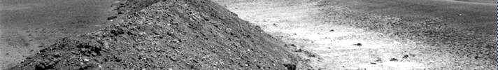
Tell Leilan is located in the northern half of the plain (Fig. 1). A significant walk-over survey and examination of the wadi system in the immediate vicinity of Leilan was conducted and included the Wadis Qatrani, Jarrah, and Silbah. Overall, exposure conditions are quite poor; the wadis are dry, and thoroughly vegetated (Fig. 5). Because of poor exposure, just one Holocene fill unit within the broader wadi channels was recognized; a brown to black sandy loam with pottery sherds. This unit forms small (0-3 m thick) terraces on the inside of wadi meanders, and has been incised during a subsequent (probably the modern) hydrologic regime. No diagnostic features were present on the pottery sherds thus inhibiting a terminus post quem age date for this unit.
Further out from Leilan, the same sequence was recognized in most wadi exposures with the exception of the cut at the YI (Yasser Ibrahim) gravel pit (Fig. 3). There, a series of channel sands and gravels indicative of a braided river channel system was recognized. Given that this locality is further to the north, and proximal to the alluvial apron being shed off of the Tur Abdin, these braided channel sands and gravels are not unexpected, and probably represent a fan distributary channel.
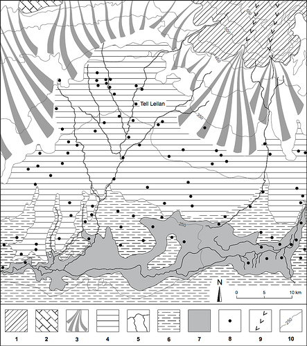 Figure 1. |
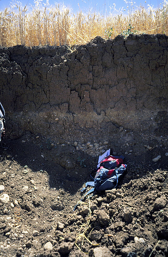 Figure 2. |
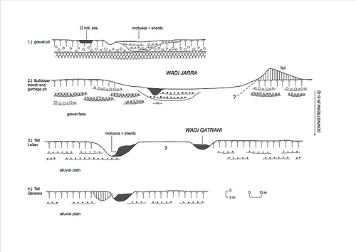 Figure 3. |
 Figure 4. |
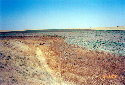 Figure 5. |
Wadi Jarrah Bulldozer Cut
Description and Stratigraphy
A 3.4 m deep bulldozer cut was made in the Wadi Jarrah channel about 5 km to the north of Tell Leilan, and provided excellent exposure of what is perhaps the complete Holocene wadi sequence (Fig. 6 and Fig. 7). However, additional field observations and wadi cuts must be made to confirm this. Three different Holocene-aged channel sequences were observed, and provide evidence for regional changes in hydrology.
The lowermost (e.g. oldest) sequence consists of a gleyed coarse sandy gravel which fines upwards to cross-stratified coarse sands with occasional clayey rip-up clasts. This is associated with an interfingering, gleyed silty clay unit. This fining upwards sequence with cross-stratified sands is a classic result of meander migration, and thus the sequence is interpreted to be from a meandering-type river channel system. Pottery fragments were encountered in the gravel lenses, but were too abraded to provide diagnostic characteristics for any age control.
The second oldest sequence consists of gravelly coarse sands, and poorly sorted gravels with clasts ranging up to 20 cm in diameter. Abundant carbonate nodules and carbonate encrustation was observed giving the sequence an overall lighter color with the exception of the uppermost gravel unit which was brown. Importantly, this sequence was present around the entire length of the bulldozer trench (~15 m long) which demonstrates that it is not a single small channel, but a broader gravel sheet. This sequence is interpreted to be from a braided-type river channel system. Abraded pottery fragments were also encountered in this sequence, but were insufficient to provide any age control.
The third and youngest sequence consists of dark brown to olive- and grayish-brown sandy silts and muds with occasional oversized gravel clasts up to 20 cm in diameter. Zones of abundant gastropod and pelecypod shells, with many of the bivalve pelecypod shells still fully articulated, were observed. This unit is interpreted to be from a meandering-type river channel system. In fact, it appears to be the same brown to black sandy loam that was observed in the wadis during the extensive wadi walk-over survey. Abraded pottery fragments were also encountered, and again were not sufficient to provide any age control.
Discussion and Water Balance Interpretations
The change ( Figure 6 and Figure 7 ) from a meandering-type channel system (oldest sequence), to a braided-type system (middle sequence), and back to a meandering-type system (youngest sequence) provides some evidence for regional changes in hydrology. Meandering systems are generally typical of more continuous, regular, lower-velocity/discharge flow regimes, and are often found in more humid environments. In turn, braided systems are more typical of irregular, flashy, higher-velocity/discharge flow regimes, and are often found in more arid environments. Thus, the braided river channel system deposit discussed above may represent a period of aridification (e.g. flashy, irregular, higher-discharge events).
Note that higher-discharge events are perhaps not a requisite for developing braided channel systems–simple aridification may lead to this. An important difference in the development of a meandering channel versus a braided channel system is vegetation. Without vegetation to stabilize the landscape and river channels, a channel system will remain braided. Normal but sporadic precipitation events may have the effective impact of a higher precipitation event because of the lack of protection afforded by vegetation. Thus, because of aridification, as regular vegetation is suppressed or completely disappears, a shift from meandering to braided channel systems may occur.
Dating opportunities for the three sequences from the Wadi Jarrah bulldozer cut were quite limited. Only some marginal carbonized organic samples were obtained. Additional fieldwork and wadi cuts might provide better samples for dating, or diagnostic pottery sherds for age control.
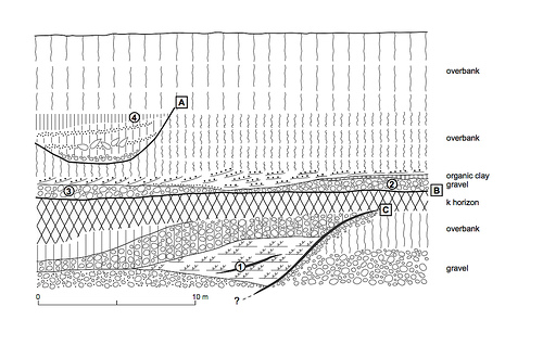 Figure 6. |
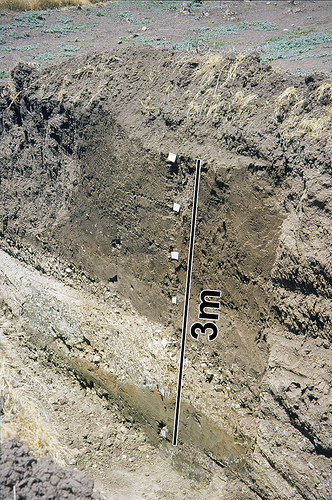 Figure 7. |
Possible Structural Controls on Alluvial Fan and Wadi Development
Field observations suggest that the growth and development of the alluvial fan and wadi system may have had some structural control, at least at certain points in the alluvial plain. In particular, north of the YI gravel pit, a basalt cliff has diverted the flow of the Wadi Jarrah causing the wadi to run along its base. The cliff there trends approximately WSW-ENE with the down side towards the north. Within the survey area which was limited to a 15 km radius from Tell Leilan, this is the only place where an obvious structural control was observed. Additional fieldwork may point to other areas where this is significant.
Proposed Activities for Future Work
To better define the Pleistocene alluvial plain and fan system, and the Holocene wadi system, and their interrelationship, additional field survey including several bulldozer-cut trenches would be necessary. In particular, optimum locations to cut trenches would be at:
- the junction of the wadis Jarrah and wadi Qatrani,
- westward from the June 2002 Wadi Jarra trench extending it towards an existing large garbage pit
(Fig. 8), - north of Leilan to examine a section similar to those published by M.-A. Courty,
- in the Wadi Radd to get an idea of stratigraphy depth there, and its importance as a depocenter.
A bulldozer-cut trench, or multiple cores, in the Wadi Radd may provide important information about the changing hydrologic regime in the region. In particular, because of the organic content of the Wadi Radd sediments and our current understanding of its geomorphological situation, it is very probable that peat or other organic swamp deposits may be found in the stratigraphy there. This would provide a significant opportunity for radiocarbon dating of the stratigraphy since appropriate material for dating should not be common at other points in the alluvial plain.
If the interpretation made above that the braided channel deposit noted in the Wadi Jarrah stratigraphy represents a period of significant aridification, it is expected that the Wadi Radd would preserve an even more pronounced record of such an event. Though no information about the depth of stratigraphy in the Wadi Radd is available, it is possible that it could be quite thin as evidenced by the small, low tells which peek out through the black earth on satellite images. Thus, simple 3-5 m deep bulldozer trenches may be sufficient, though this figure may change when a trench is actually cut.
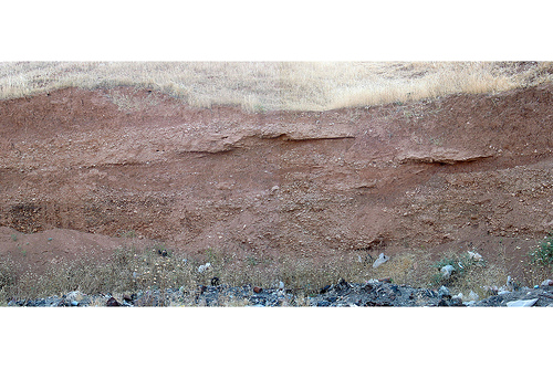 Figure 8. |