The Excavations at the City Gate were conducted in May-June 2002 by Lauren Ristvet (University of Cambridge) and Andrew McCarthy (University of Edinburgh), under the Direction of Prof. Harvey Weiss (Yale University). These pages represent a preliminary report for Operation CG and a condensed version of the final analysis, which is in preparation for publication.
Contributing to the report are: Mark Besonen (University of Massachusetts), Mauro Cremaschi (University of Milan), Dominique de Moulins (University College London), Andrew McCarthy, Cristiano Putzolu (Roma), and Lauren Ristvet. Many thanks go to Prof. Weiss for his support of this project.
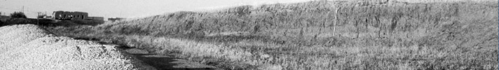
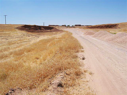 Figure 1. |
Introduction
This preliminary report provides a summary of the excavation and subsequent analysis of the 3rd-2nd millennia city gate area at Tell Leilan (Fig. 2). This excavation was essentially a rescue project, launched after road construction had damaged this area. The studies presented here are in the precarious position of being part of a discreet excavation operation and being subject to limitations in exposure and problems encountered trying to salvage archaeology from massive modern disturbance. At the same time, the results, made possible by a generous investment of resources by Prof. Harvey Weiss, are enlightening not only for the understanding of the archaeology at Tell Leilan, but also for our understanding of the development of culture in this region and the Near East in general.
Between ca. 2600 B.C. when the foundations for the city wall were first laid, and ca. 1700 B.C., when this complex was permanently abandoned, Northern Mesopotamia witnessed an extraordinary sequence of political, economic, and social transformations. It is no coincidence that the city wall was constructed at 2600 B.C., the same time that Tell Leilan experienced an “urban revolution”, which resulted in the transformation of the site from a 15 hectare town to a 90 hectare planned city. Similarly the traces of an entrenched bureaucracy, recovered from the city gate excavation, echoes the evidence of a new political structure suggested by excavations on the Leilan acropolis (Calderone and Weiss 2003).
Both the growth of this site, and the creation of its fortifications were not unique events, rather they occurred as part of a general pattern of urbanization and state organization in the Habur plains. Walled, planned cities also arose at Chuera, Beydar, Hamoukar, Mozan, Khoshi, and Taya at the same time (Weiss 1986; Dohmann-Pfälzner and Pfälzner 1996; Lebeau 1997; Meyer 2002; Ur 2002). Likewise, the rebuilding of the city fortifications at approximately 2300 B.C. corresponds to the refurbishment and new construction at the cultic platform complex at the Acropolis Northwest during the same period; both provide evidence for the Akkadian imperialization of this city (Ristvet and Weiss 2000; Weiss et al. 2002; Ristvet and Weiss N.D.). The layers of dust which piled against the abandoned walls during the occupation hiatus around 2200-1900 B.C. are contextualized by the similar abandonment seen throughout the Habur triangle, and Northern Mesopotamia (Weiss 2000). Finally, the slapdash rebuilding of the city fortifications during the early second millennium B.C. corresponds with the revival of this city as Šubat-Enlil, Šamši-Adad’s capital. The historical circumstances shed light on the shifting construction and use of this area. In turn, our excavation at the city gate provides new data which helps to refine our theories of state development, urbanization, exploitation of power, and collapse.
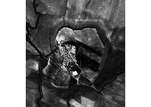 Figure 2. |
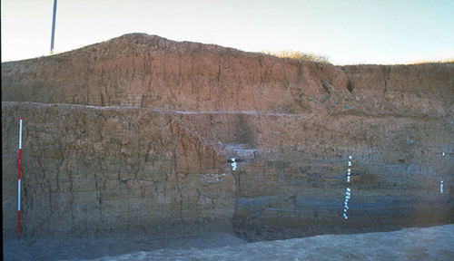 Figure 3. |
Works Cited
- Calderone, L. and H. Weiss (2003). “The End of the Ninevite 5 Period at Tell Leilan.” in The Origins of Northern Mesopotamian Civilization: Ninevite V Economy, Society and Culture. ed. by H. Weiss and E. Rova. Subartu. 9 Turnhout: Brepols.
- Dohmann-Pfälzner, H. and P. Pfälzner (1996). “Untersuchungen zur Urbanisierung Nordmesopotamiens im 3. Jt. v.Chr.: Wohnquartierplanung und städtische Zentrumsgestaltung in Tall Chuera.” Damazsener Mitteilungen 9: 1-13.
- Lebeau, M. (1997). “La situation géographique, la topographie et les périodes d’occupation de Tell Beydar,” pp. 7-20 in Tell Beydar, Three Seasons of Excavations (1992-1994): A Preliminary Report. ed. by M. Lebeau and A. Suleiman. Subartu. 3 Turnhout: Brepols.
- Meyer, J.-W. (2002). Town planning in 3rd millennium Tell Chuera. Paper presented at Power and Architecture: Monumental Public Architecture in the Bronze Age Near East and Aegean, Leuven, Belgium.