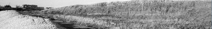
Tell Leilan is located on the Habur Plains of northeastern Syria (Fig. 1). The city’s outer fortifications rise from 5 to 15 meters above the level of the surrounding plains, extending for 3.7 kilometers and enclosing an area of 90 hectares (Fig. 2, Weiss 1990d: 529). In spring 2002, road construction resulted in bulldozer damage to the northern outer rampart fortification area where the main entrance to the city once lay. Excavations were conducted from 23 May 2002-21 June 2002 to investigate the section made by the bulldozer and explore the construction history of the city gate.
 Figure 1. |
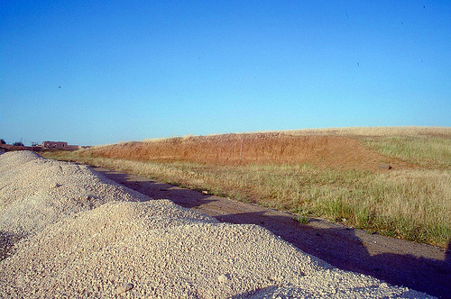 Figure 2. |
Methodology
Both the east-facing and west-facing sections were cleaned and examined, but it became apparent that the deeper west-facing section provided a better section cleaning and excavation opportunity. The height of the fortification area, and the existing damage limited excavation and investigation to the pre-existing cut. This made using a standard grid-system untenable. The section cleaning and excavation took place in several areas in front of the west-facing section; the majority of the section was cleaned, studied, drawn and photographed, and portions of the section were excavated stratigraphically. The bulldozer cut of the west-facing section spanned approximately 30m in length (north-south), and the 2002 Operation CG City Gate) excavations systematically studied nearly 80% of this cut.
We used two different recovery methods while excavating a 24 meter length of bulldozer damage. The phasing and stratigraphy of the operation was established in the central area, 9 meters long, 1 meter wide, and 3 meters high
( Figure 8 ). Since we had already cleaned the area west of the central area down to virgin soil prior to excavation, we were able to designate excavation units and plan recovery techniques. This area was divided into 47 stratigraphic units (lots), 23 of which consisted of floor material, ashy deposits or other unusual deposits (such as 110, a dense deposit of burnt barley seeds). All material recovered from these deposits was either floated or dry-sieved to recover botanical materials and small remains respectively. 10% of the remaining 24 units were dry-sieved, while 5% of these lots were floated. Soil micromorphology samples were taken from the floors of each phase, as well as from other geologically interesting contexts. Two additional meters to the west and 15 additional meters to the north and south were excavated using normal excavation procedures. Floors were carefully cleared and all material on them saved and dry-sieved. Deposits, which sealings were sieved, and ash deposits were saved for flotation.
We have carefully combined the analysis of the two excavated areas using a simple GIS. The detailed sections, which allowed us to prepare our excavation of the central section, along with plans of each phase, and daily digital photographs have formed the basis of this excavation tool. The GIS streamlined both the excavation and subsequent analysis of this operation. It has allowed us accurately to measure the dimensions (including volume) of each lot and feature found within the excavation area (Fig. 3 and Fig. 4).
 Figure 3. |
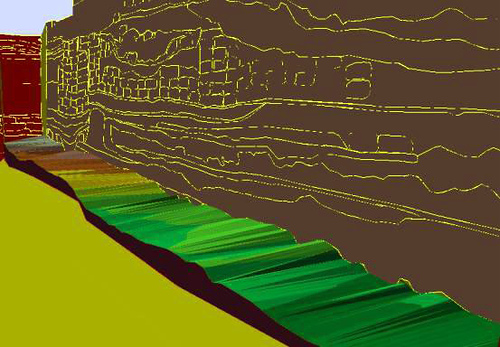 Figure 4. |
Construction History of the Fortifications
The initial stage of this fortification system is characterized by a set of earthworks situated on a slight N-S slope. These consist of two artificial mounds, which were constructed from the red virgin soil of the plains in two phases
(Fig. 5 and Fig. 6). These earthworks were originally 4m thick and 3m high. Wall A- a massive mudbrick fortification wall for the city and its gate complex-was cut into these mounds, which served as a glacis. Wall A was 3m wide and preserved to a minimum height of 3 m. It was carefully constructed of alternating red and black bricks, and served as the main north wall of the city gate area for approximately three centuries from ca. 2600-2300 B.C.-until W-B was constructed adjacent to it during the Akkadian rebuilding project. W-B is built of narrow red-brown bricks and is a much smaller wall-only 1.04 meter thick and preserved to a height of 1.75 meters. Limited excavation revealed that this wall was buttressed by at least one short return, which added another meter to the width of this wall.
On the southern side of the mound, the probable southern limits of these fortifications were explored (Fig. 7). Wall K, An E-W wall, 3 meters wide, delimits the apparent southernmost extent of the City Gate complex. This wall is stepped to the north in a manner similar to the way W-A was stepped to the south. The bricks are similar to those of W-B, and stratigraphically dated to the Akkadian period (2300-2200 B.C.). Between W-A and W-K lay a series of spaces, alternately roofed and open air, which formed the administrative quarter of the city gate complex during the late third millennium, Leilan periods IIId, IIa and IIb.
 Figure 5. |
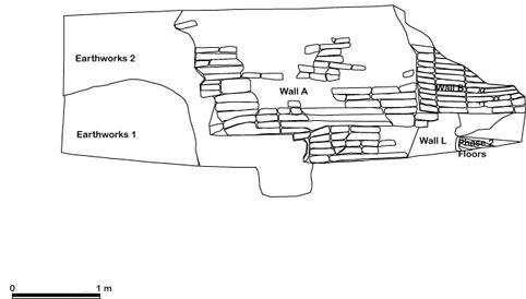 Figure 6. |
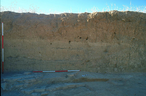 Figure 7. |
Phasing
Our excavation revealed 9 phases of the city gate complex, dating from the mid-third (Period IIId, terminal Ninevite 5) to the early 2nd millennium (Period I, Habur ware) ( Figure 5 and Figure 6 ). The phasing, from latest to earliest, is as follows (Fig. 8) and Table 1):
| Phase Number | Leilan Designation | Phase Description | Associated Contexts |
|---|---|---|---|
| 9 | Period I | 2nd Millennium Earthwork Rampart | 1 |
| 8 | Habur Hiatus I | Post-Akkadian Hiatus | 2-3 |
| 7 | Period IIb | Post Wall D | 101, 132, 133, 4-6, 17, 20-21, 27 |
| 6 | Period IIb | Wall B - Wall D | 102, 103.1-5, 104, 139, 140 |
| 5A | Period IIa | Post-Wall C | 106, 108, 109, 110, 111 |
| 5 | Period IIa | Wall C - Baked-brick Platform | 105, 112, 113, 115, 116, 117, 118, 119, 141, 142 |
| 4 | Period IIa | Wall C -Wall E | 120, 121, 122, 123, 134 |
| 3A | Period IIa | Tanour 125 - Wall E | 124, 125.1-2, 134.1, 143, 144 |
| 3 | Period IIa | Wall G - Wall E | 126, 127 |
| 2 | Period IIId | Wall A - Wall I - Wall G | 128, 129 |
| 1 | Period IIId | Initial | 130 (Virgin soil is 131) |
Table 1: Description of Op. CG phases
Phase 1 - Initial Phase (Leilan IIId)
Phase 1 dates to the building of the wall complex and is characterized by a few small scattered fireplaces, one of which has a small mudbrick firebreak. This phase included some of the only animal bones found during excavation, as well as a few broken container sealings-showing only the impression of basket weave and knots. The pottery includes several examples of late excised Ninevite 5 designs, as well as Ninevite 5 fingernail impression patterns.
Phase 2 - Wall A - Wall I - Wall G (Leilan IIId)
This area was quickly converted into government offices once Wall A, the northern fortification wall, was completed. One mudbrick and two pisé walls were built up to partition the space between the two fortification walls. Between these walls lay a series of floors and an ashtip (Fig. 9 and Fig. 10 ).
Phase 3 - Wall G - Wall E (Leilan IIa)
This phase saw a continuation in the function of this area. More dividing walls were constructed, especially in the south and west, but these walls continued to be used to partition the ashtip. This phase is defined largely by the construction of Wall E, which was built directly on the ashy deposits of the ash tip. Wall E was built parallel to W-A, and was constructed of the same alternating black and red bricks. There seems to be a narrow space between Wall G and Wall A, during this period, probably forming a walkway along the city wall ( Figure 10 ).
Phase 3A - Tanour 125 - Wall E-Bin 143 (Leilan IIa)
During Phase 3a a pebble and sherd-lined tanour and a sherd-lined bin were dug into the ash-tip (Fig. 11 ). During this subphase, the two pisé walls fell out of use. Ash from the tanour may have been periodically emptied into the tip.
Phase 4 - Wall C - Wall E (Leilan IIa)
During phase 4, two new walls were built and the ashtip fell out of use. Wall C was built on top of the features and deposits of Phase 3A ( Fig. 10 and Fig. 12). The orientation of Wall C is identical to one of the earlier pisé walls, although in this phase it appears as if the space between Walls C and E served a different purpose than simply an ash tip. While some ashy layers are present, they are not as concentrated nor as deep as in the earlier phases, and instead seem to define living surfaces. Wall C is 1.1 m wide, and made of whole and half red and black bricks like Walls A and E. It is likely that Wall C initially served as the wall of a room or building and that 121 represents an interior surface. The space between Walls C and A, noted in the previous phase, persisted. A series of washed-out floor-like deposits (134) further suggest that this area continued in use as an alley-way between the office space of Walls C and Walls E and the outer fortifications.
Phase 5 - Fireplace and Baked Brick Platform (Leilan IIa)
During phase 5, the function of this area shifted dramatically, due to the construction of two features, an enormous, 3 meter wide, purpose-built fire-place in the north, which incorporated W-C in its construction, and a baked-brick platform to the west and south. Both of these features, along with a drain (141), suggest that this area was now open-air. In an excavated area to the south of the central section (Area 1), the baked brick platform (38, 117) is built with a drain and is associated with a cobbled surface ( Figure 12 ). In-between Walls A and C, the space apparently continued in use as a pathway running parallel to the fortification wall, similar to previous phases. To the south, a fireplace installation (115) was made of grey/black mudbricks and lined with a thick orange mud-plaster facing (114); it was also built upon a thick plaster floor (119), as was a portion of the baked-brick platform. The central portion of this fireplace was constructed of three courses of bricks (approximately 2 meters wide, while at the north and south ends were two pedestals, eight and seven bricks high respectively (and 1 meter wide). In the north, these bricks were laid next to, and on top of W-C. This created a consciously constructed central depression in which a series of burning layers is attested (112). South of the southern pedestal, a double row of gray bricks continues for another meter after the southern pedestal (see photograph to the right). These form a surface flush with the baked-brick (117) and cobble (118) platform, which continued both south and west to the limits of excavation. A purpose-built drain (141), which runs from east to west (according to the slope) was built into this double row of mudbricks. Another cobble drain lay in the west, built north to south. The baked bricks of this platform were heavily worn and difficult to articulate in plan, probably as a result of considerable traffic. This platform may have formed the surface of the road entering Tell Leilan, or at least entering the gate precinct.
Phase 5A - Trash Deposition (Leilan IIa)
Following the use of the baked brick platform, this area was abandoned for a short time, and trash deposits were dumped here. These include lot 110, the so-called ‘seed layer’, named thus after the density of burnt barley seeds found throughout its matrix (Fig. 13).
Phase 6 - Akkadian Rebuilding (Leilan IIb)
Phase 6 represents a rebuilding and re-investment in the gate complex architecture and a renovation of the outer fortifications. Construction techniques and associated pottery date this phase to Leilan IIb (see pottery analysis). Walls B and D, both made of similar red mudbricks (of entirely different appearance than those from earlier phases), were finely constructed and serve to replace or to repair the earlier structures. W-B is a rebuilding of the outer foundation wall, while W-D was built above W-E ( Figure 13 ), and serves to delineate space within the wall complex. A tanour is the only feature within the space between Wall B and Wall D, 9m to the south. A series of floor deposits is evident but little else was revealed. A stamp sealing was found in 102, the brick-collapse relating to this phase.
Phase 7 - Later Akkadian Floors (Leilan IIb)
Strata that overlay Wall D but are still associated with Wall B are assigned to this phase. This phase is represented by surface deposits consisting of sherds and a few patches of ash. Due to bulldozer damage, only a very limited exposure of this phase was made.
Phase 8 - Post-Akkadian Hiatus (Habur Hiatus 1)
This thick deposit overlays Phase 7, Wall B and any remaining layers associated with architecture. The soil matrix is surprisingly clean and pale colored, with little cultural material, save a few scattered small concentrations of sherd layers similar to the sherd layers found in Phase 7. The composition and appearance of the matrix stays consistent for nearly a meter before it very starkly contrasts with the overlying Phase 9 red earthworks (Fig. 14). A clear line can be seen between Phases 8 and 9 for the entire 30 meters of the west-facing section. This layer has been called the post-Akkadian hiatus to correspond with similar deposits found elsewhere at Tell Leilan and at other sites. Numerous soil samples were taken and the analysis is in progress.
Phase 9 - The 2nd Millennium Earthwork Rampart (Leilan I)
This phase witnessed the construction of a new set of earthworks made of red soil which covered the entire city gate area ( Figure 14 ). There are no structures that are associated with this phase, as the red soil earthwork literally covers all of the preceding architecture. At the same time, it can clearly be seen in the section that the construction of the mound must have taken place in discreet stages, as there are concentrated sherd deposits and other floor-like layers intermixed.
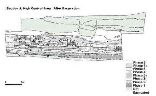 Figure 8. |
 Figure 9. |
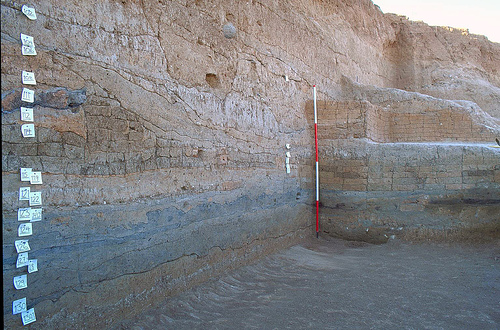 Figure 10. |
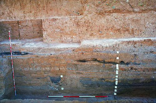 Figure 11. |
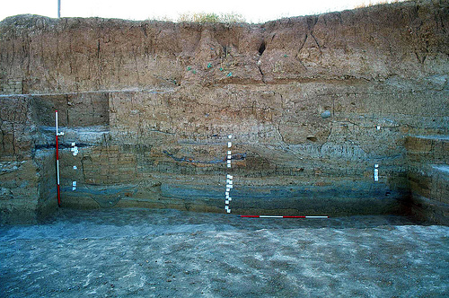 Figure 12. |
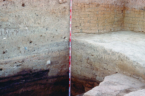 Figure 13. |
 Figure 14. |