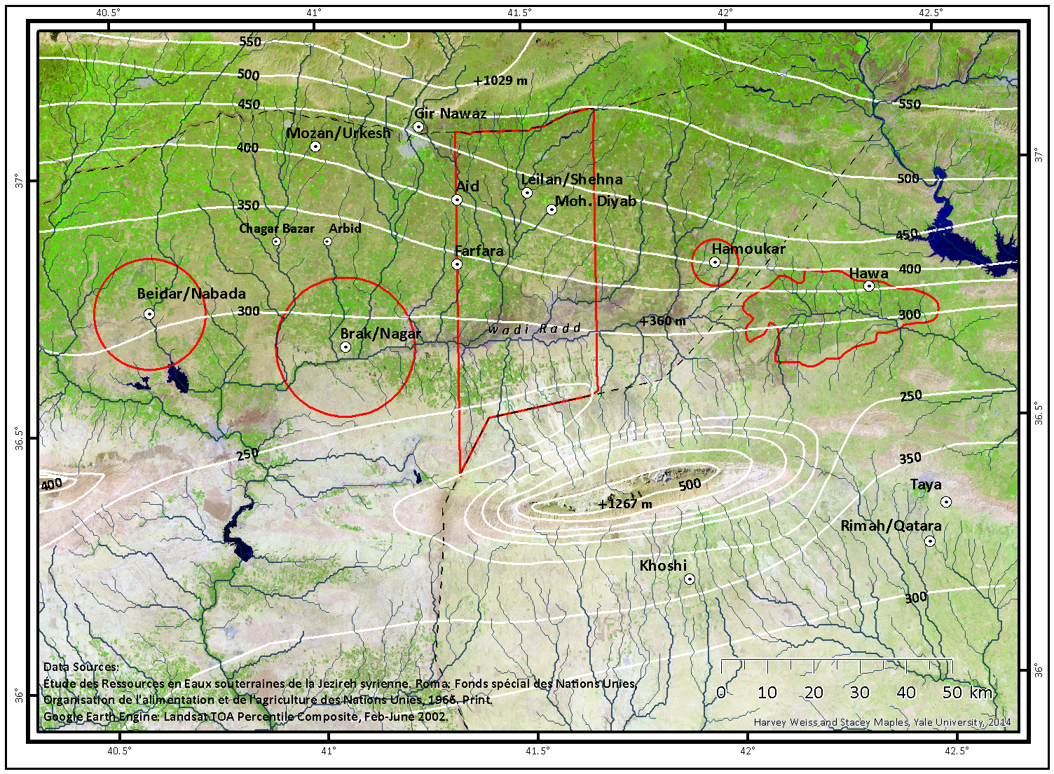
Systematic, total coverage, regional survey has been developed over several seasons of fieldwork across a 30 kilometer wide transect totaling 1650 square kilometers and extending from the Iraqi border to the south and to the Turkish border to the north:
1984 Charles A. Forrest, Mohammed Muslim, Harvey Weiss
1987 Gil Stein, Patricia Wattenmaker
1993 M.-A. Courty, Harvey Weiss
1995 M.-A. Courty, Peter deMenocal, Suzanne Leroy, Harvey Weiss
1997 Elena Rova, Richard McNeill, Harvey Weiss.
The survey collections are now stored, through the cooperation of the Directorate-General of Antiquities, SAR, in:
- Tell Leilan Project expedition house, Qahtaniya
- Tell Leilan Project Survey laboratory, Università di Venezia
- Tell Leilan Project Laboratory, Yale University.
Continuing analyses of the collections at the three storage facilities include:
- Lauren Ristvet, University of Pennsylvania, third-second millennia BC;
- Elena Rova and students, Università di Venezia, Islamic, Neo-Assyrian, Mitanni. Five theses analysing period-wise distributions have already been completed or are close to completion:
- Donella, Viviana 2003 La ceramica mitannica e medio-assira della ricognizone di Tell Leilan (Siria nord-orientale), Tesi di Laurea specialistica in “Archeologia e Conservazione dei Beni Culturali”, Università Ca’ Foscari Venezia, Anno Accademico 2001-2002.
- De Aloe, Ilaria 2003 Un’analisi delle ceramiche dalla ricognizione di Tell Leilan -Siria nord orientale- nel contesto dellalta Mesopotamia tra Ellenismo ed età sassanide, Tesi di Laurea quadriennale in Conservazione dei Beni Culturali, Anno Accademico 2002/2003.
- Vezzoli, Valentina 2004 L’insediamento di epoca islamica nell’area di Tell Leilan (Gazira settentrionale): studio del materiale ceramico, Tesi di Laurea quadriennale in “Lingue e Civiltà orientali”, Università Ca’ Foscari Venezia, Anno Accademico 2003-2004.
- Brustolon, Anna in prep. La ceramica del Tardo Calcolitico della ricognizone di Tell Leilan (Siria nord-orientale), (provisional title), Tesi di Laurea quadriennale in “Conservazione dei Beni Culturali”, Università Ca’ Foscari Venezia, Anno Accademico 2003-2004.
- Gavagnin, Katia in prep. La ceramica neo-assira della ricognizone di Tell Leilan (Siria nord-orientale), (provisional title), Tesi di Laurea specialistica in “Archeologia e Conservazione dei Beni Culturali”, Università Ca’ Foscari Venezia, Anno Accademico 2003-2004.
- Dr. Ferran Borrel Tena, Barcelona, PPN and earlier lithic collections.
- Monica Arrivabeni, Freie Universitat Berlin
The survey has used LANDSAT, SPOT and CORONA imagery, GPS-fixed site coordinates, and SAR topographic maps ranging from 1:100,000 to 1: 10,000. Topographic plans of individual sites were mapped by Gil Stein and Patricia Wattenmaker in 1987, and by Richard McNeill and Harvey Weiss in 1995 and 1997 using a Leitz total station. LRS data and analyses have been published in Weiss 1986, Stein and Wattenmaker 1991, Weiss et al 2002, Weiss 2003, Ristvet and Weiss 2005, Ristvet 2005, Arrivabeni 2012, Ristvet 2012, Weiss 2012, Sanders 2015.
The preliminary regional settlement maps[PDF]
The field-recorded data, most 1995 and 1997, were assembled by Lauren Ristvet, with assistance from Mark Besonen, for Leilan periods IV-I. These ceramic periods have been defined using Leilan-excavated stratigraphic ceramic assemblages analyzed in Schwartz 1988 (Ph.D. diss., Yale), Senior and Weiss 1992, Senior 1998 (Ph.D. diss., Arizona), Ristvet 1999 (B.A. thesis, Yale), Pulhan 2000 (Ph.D. diss., Yale), Ristvet and Weiss 2000, Calderone and Weiss 2003, Mayo and Weiss 2003, Ristvet and McCarthy 2002, Ristvet, Guilderson and Weiss 2004, Ristvet 2005 (Ph.D. diss., Cambridge), and Reade 1982 for the Leilan IIc assemblage that is Taya VI.
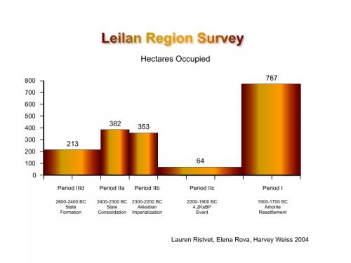
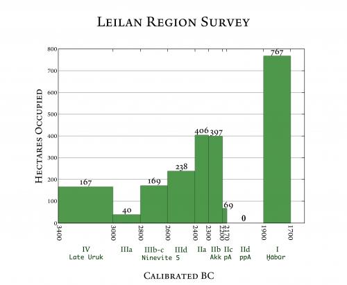
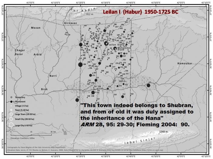
Immediately visible in these regional settlement maps are some of the most significant events and processes of ancient Mesopotamian history:
- the Period IV Late Uruk (3400-3000 BC) collapse visible in succeeding Leilan IIIa (3000-2800 BC)
- regional secondary state formation in Leilan IIId (2600-2400 BC)
- the Akkadian imperialization of Šehna in Leilan IIb (2300-2200 BC)
- the Akkadian collapse (šulum Akkadê) and abandonments visible in Leilan IIc and Leilan IId (2200-1900 BC) during the global 4.2 ka BP abrupt megadrought event
- the Amorite resettlement, of the abandoned landscape at Šubat-Enlil/Šehna, Apum during Leilan I (1900-1700 BC)
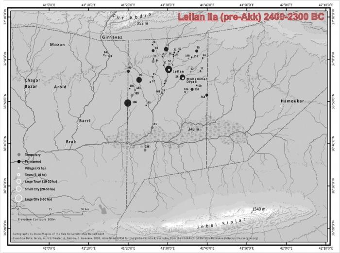
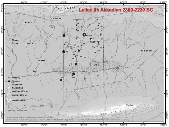
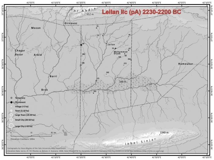
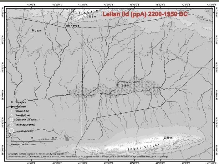
These regional settlement data are summarized in the histogram of hectares occupied/ceramic time period .
What accounts for the difference between these two histograms? Detailed analyses of LRS site assemblages (Arrivabeni 2012; Ristvet 2012) – and 90 radiocarbon dates (Weiss et al 2012) that constrain the duration of the Leilan IIc/post-Akkadian period.
“Routes rayonnantes”
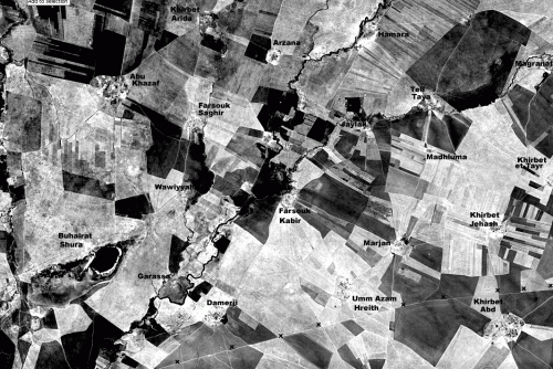
The settlement transformations of the Leilan region landscape through time can be disarticulated with remotely sensed data, including LANDSAT and CORONA imagery .
For example, the satellite imagery reveals:
- the remnant Ottoman landholding system (rectangular fields)
- 1958 and 1962 land redistributions (pie-wedge fields)
- tracks and roads which link villages of Jawala, Hreith, Bou Hamis, Bou Habib, el-Hbeith, and Rashid tribes people (all of the Tayy) that were founded in the 1950s and 1960s.
These data contribute to understanding the van Liere and Lauffrray (1954/1955) “routes rayonnantes” that have vexed archaeologists for decades. Ground-truth observations of satellite imagery have been complemented with archaeological surface survey, and villagers’ oral histories recorded region-wide. For instance, Tell Garassa, 15 kilometers south of Tell Leilan on the west bank of the wadi Jarrah, was a regional center from Halaf through Islamic periods. The village of Damerji, on the east bank of the wadi Jarrah, was founded ca. 1951 by Hreth villagers. There is no archaeological site at Damerji, and there is no modern village at Tell Garassa. On van Liere and Lauffray’s map (1954/1955), however, Damerji is the nexus of their “routes rayonnantes” that have been superimposed here upon the satellite imagery. The “routes rayonnantes” also extend towards Mazluma, a modern village, mostly Kurdish, founded in 1951, which lacks any previous, archaeologically detectable, settlement.
Perhaps most instructive, however, is the distribution of ancient occupations among the Garassa region’s ten sites linked with “routes rayonnantes”:
| 1. QARASSA | Halaf/Ubaid-Islamic |
| 2. DAMERJI | Modern: Hreth of the Tayy village, founded ca. 1951 |
| 3. ABTAKH TAHTANI | Hellenistic. |
| 4. KHORMOR 1 | Ubaid, Hellenistic |
| 5. KHORMOR 2 | Ubaid, Hellenistic |
| 6. ABTAKH FAWQANI | Habur, Nuzi, Hellenistic |
| 8. MARJAN | Ubaid, Habur, Islamic |
| 9. MAZLUMA | Modern: Kurdish village, founded ca. 1951 |
| 10. JAYLAK | Ubaid, Hellenistic/Roman. |
The occupations of sites that are not linked with “routes rayonnantes” are similarly revealing:
| 1. KHIRBET JEHASH | Hellenistic/Roman |
| 2. TAYIR | Halaf/Ubaid, Leilan II, Habur |
| 3. FARSUK KABIR | Leilan IIIb/c, Leilan II |
| 4. ABTAKH FAWQANI | Habur, Nuzi, Hellenistic/Roman. |
These “routes rayonnantes” link ancient sites occupied asynchronously and do not link sites occupied synchronously —apart from some recent modern villages. These “routes rayonnantes” are, therefore, not roads linking third millennium BC settlements, but tracks linking modern villages. After these observations were made, W.J. van Liere , in a telephone conversation from his home in Thailand, remarked, “Ignore the ‘routes rayonnantes’; they are modern sheep tracks.”


