Introduction
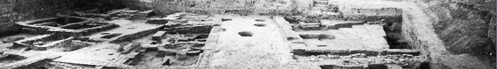
One season of excavation at Operation 5 (1989) in the southern part of the Lower Town uncovered part of a third millennium neighborhood (Fig. 1). Several houses and workshops lined both sides of a straight, wide street which linked this residential area to the public buildings on the Acropolis. Excavations exposed eight phases of this area-from its founding on virgin soil at ca. 2600 BC (Leilan IIId) to its abandonment at ca. 2200 BC (Weiss 1990). The excavation of this worker’s quarter provides new information for Leilan’s explosive growth from a 15 ha town to a 90 ha city. It sheds light on the nature of early urbanism and state formation, and how these processes changed how ordinary people lived. Furthermore, by comparing the results of the third millennium excavation at the Lower Town South with those on the Acropolis and at the City Gate, we can analyze class differences and social stratification (Weiss et al. N.D.). Finally, data from this excavation encourage us to frame new questions about why state formation occurred, and why it happened when it did.
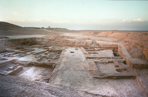 Figure 1. |
 Figure 2. |
The History of the Lower Town South Neighborhood
The excavation exposed 600 m2 of a dense, third millennium neighborhood (Weiss 1990). The sequence of occupations can be seen in the south baulk of 77F01 (77F01 South Section LTS.jpg). 10 of the 13 phases date to the mid-late third millennium. The first three phases represent modern top soil (phase 1), a possible medieval occupation (phase 2), and an erosion/dust layer atop the final third millennium layer (phase 3).
Phase 4: The latest third millennium phase is poorly preserved and consists of portions of baked brick walls, platforms and baked clay drains. This might comprise a workshop area, although since most of the mudbrick architecture of this phase has probably eroded away, this is not certain. This phase dates to Leilan IIb (2300-2200 BC)
Phase 5: The phase 5 settlement remains are comprised of the wide NW-SE street and contemporary mudbrick houses (Fig. 3). Along both sides of the 4.5m wide sherd-paved street are mudbrick walls that limit access to this street. These walls delimit two quarters on either side of the street. On the eastern side of the street are two houses (buildings 1 and 2), separated by an alley. Beneath a sherd-paving, a drain in the alley channeled waste from east to west into the street. No entrances are available to these houses from the street. They probably had entrances onto the alley, but they were not retrieved in the excavation. Two poorly preserved walls are part of a third structure in the southern part of 77F01, although the nature of this structure could not be clarified (building 7). On the western side of the street are the remains of at least four houses, separated by other sherd-paved alleys with drainage pipes. Building 6 featured large grain storage bins or bread kilns. This phase also dates to Leilan IIb (2300-2200 BC).
Phases 6 and 7: Only about 180m2 of this phase were uncovered, but they show that the nature of this area was the same during the Leilan IIa phase-and that it consisted of houses and associated workshops (Fig. 4). A long east-west dividing wall divided the area west of the street into a northern and southern quarter. The southern sector probably contained portions of single room houses (buildings 9-11), which used this wall as their common northern wall. To the north, building 8, built against the western street wall was the best-preserved building found in the Lower Town South. A catastrophic fire had destroyed this house, leaving the inhabitants no time to save their belongings. As a result, the excavations uncovered whole pots, stone tools and a carefully plastered work area, lying where they had the last time the house’s inhabitants had used them.
Phases 8-12: In a test trench, four earlier floors of the street were retrieved, indicating that the plan of this area remained basically the same from its foundation at ca. 2600 to its abandonment at ca. 2200 BC. The street was thus a fundamental component of the earliest settlement of the Lower Town South.
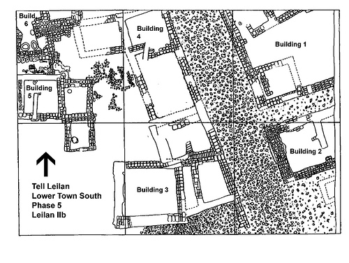 Figure 3. |
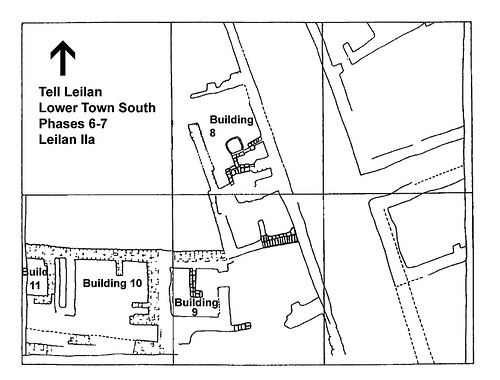 Figure 4. |
State Formation at Tell Leilan
What does the evidence from this worker’s quarter tell us about urbanization and state formation in the mid-third millennium BC? The Leilan Lower Town South excavation, along with other soundings in the Lower Town and at the City Gate dates the six-fold increase in the size of this city, from 15 ha to 90 ha, to 2600 BC. It shows that this growth did not happen gradually or piece-meal, but was planned. The street uncovered in the Lower Town is no doubt one of a number of radial streets, which were constructed at the time of the initial settlement of this area. Magnetometry surveys at Chuera and Mozan, two other cities of similar size located to the west of Leilan have confirmed the presence of radial streets in Northern Mesopotamian cities (Akkermans and Schwartz 2003).
The Lower Town South excavation is not the only place that has provided evidence for the role of central planning in the city’s growth. Excavations at the City Gate revealed that the earliest Leilan city wall was constructed during Leilan IIID-probably simultaneously with the construction of the radial system of streets. Finally, excavations at the Acropolis Northwest indicate that the Acropolis was fortified and a palace was constructed at the same time that the neighborhoods of the Lower Town were planned (Weiss 1990).
Indeed, cities sprang up across the plains of Syria and Northern Mesopotamia at 2600 B.C. (Weiss 1986) The great number of large sites that appeared in the Habur Plains testifies to the profound changes which this region underwent during the mid-third millennium BC. Prior to their excavation, archaeologists had hypothesized that these fortified third millennium cities were mostly empty (Lyonnet 1998). The Lower Town South excavation, however, documents these nascent cities densely settled west.
The Lower Town South excavation also provides evidence for the consolidation of state power after 2600 BC. A study of the pottery from the Lower Town South indicates that around 2500 BC, there was a major break in the ceramic production traditions at Tell Leilan. Incising and excising disappear and new wares and shapes are introduced, heralding Leilan IIa. This suggests that the new social and economic forces that the state unleashed did not immediately change material culture. Indeed, the effects of state formation on ceramic workshop production are most visible almost 200 years after the Lower Town South was settled, during the Leilan IIa phase.
The house types from the Lower Town South may show a similar late response to these changes, although the small size of the phase 8-12 soundings makes it hard to be definitive (Fig. 5). An analysis of houses from the mid-third millennium BC in the Jezirah has indicated that the length of the side of these houses that faced the street were standardized according to the Babylonian nindan measurement (Pfälzner 2001). This is true for Building 8 in phase 7, and maybe true for some of the phase 6 and phase 5 houses as well. This probably indicates that some urban authority was in charge of delineating house lots (Pfälzner 1997).
Similarly, the Lower Town South excavation indicates some of the changes that this site experienced under Akkadian domination. The burnt barley and wheat seeds found within the phase 5 houses provide intriguing evidence of the state’s role in the lives of its citizens. Very little evidence of cereal cleaning was found in the samples of carbonized seeds analyzed in the Lower Town South, indicating that residents of this neighborhood received already processed grain-probably in the form of rations (Fig. 6) (Weiss et al. 1993; Weiss et al. 2002). The evidence from the plant remains corresponds nicely with the emergence of a new ceramic type during this period. Three sizes of straight-sided, flat, well-fired “sila-bowls” are typical of Leilan IIb in the Lower Town South. These standard sizes correspond to the Akkadian volume measurement, the “sila” (Senior and Weiss 1992; Senior 1998).
Finally, the Lower Town South excavation encouraged us to question the collapse of Akkadian imperial organization in the north and the concomitant settlement collapse in the Leilan region. Quantifying and explaining this collapse has been a major research aim of the Tell Leilan project since 1989.
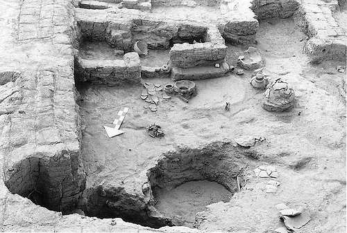 Figure 5. |
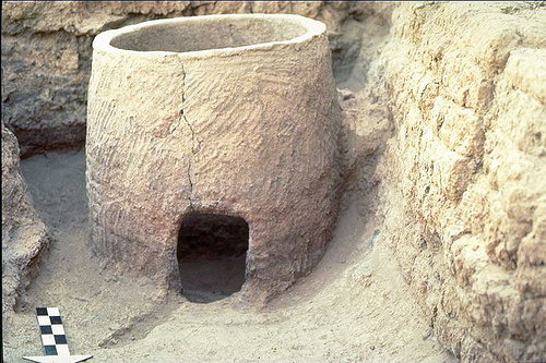 Figure 6. |
Works Cited
- Akkermans, Peter M.M.G., and G. M. Schwartz. 2003. The Archaeology of Syria: From Complex Hunter-Gatherers to Early Urban Soceties (c.16,000-300 BC). Cambridge: Cambridge University Press.
- Lyonnet, Bertille. 1998. Le peuplement de la Djéziré occidentale au début du IIIe millénaire, ville circulaires et pastoralisme: questions et hypothèses. In About Subartu, Studies devoted to Upper Mesopotamia/ À propos de Subartu, Études consacrées à la Haute Mésopotamie, edited by M. Lebeau. Turnhout: Brepols.
- Pfälzner, Peter. 1997. Wandel und Kontinuität im Urbanisierungsprozess des 3 Jtsds. v. Chr. in Nordmesopotamiens. In Die Orientalische Stadt: Kontinuität, Wandel, Bruch, edited by G. Wilhelm. Saarbrücken: Saarbrückische Drückeri und Verlag.
- ——. 2001. Haus und Haushalt: Wohnformen des dritten Jahrtausends vor Christus in Nordmesopotamien, Damaszener Forschungen. Mainz: Verlag Phillip von Zabern.
- Senior, Louise. 1998. Time and Technological Change: Ceramic Production, Labor, and Economic Transformation in a 3rd Millennium Complex Society (Tell Leilan, Syria). PhD dissertation, Department of Anthropology, University of Arizona, Tucson.
- Senior, Louise, and Harvey Weiss. 1992. Tell Leilan “sila-bowls” and the Akkadian Reorganization of Subarian Agro-Production. Orient-Express 1992 (2).
- Weiss, Harvey. 1986. The Origins of Tell Leilan and the Conquest of Space in 3rd millennium Mesopotamia. In The Origins of Cities in Dry-Farming Syria and Mesopotamia in the Third Millenium B.C., edited by H. Weiss. Guilford, CT: Four Quarters Press.
- ——. 1990. “Civilizing” the Habur Plains: Mid-Third Millenium State Formation at Tell Leilan. In Resurrecting the Past, edited by P. Matthiae, M. Van Loon and H. Weiss. Leiden: Nederlands Historisch-Archaeologisch Insitut voor het Nabie Oosten.
- ——. 1990. Tell Leilan 1989: New Data for Mid-Third Millennium Urbanization and State Formation. Mitteilungen des Deutschen Orient-Gesellschaft 122.
- Weiss, Harvey, Marie-Agnes Courty, Wendy Wetterstrom, F. Guichard, Louise Senior, Richard Meadow, and Anne Curnow. 1993. The Genesis and Collapse of Third Millennium North Mesopotamian Civilization. Science261:995-1004.
- Weiss, Harvey, Francesca deLillis, Dominique deMoulins, Jesper Eidem, Thomas Guilderson, Ulla Kasten, Torben Larsen, Lucia Mori, Lauren Ristvet, Elena Rova, and Wilma Wetterstrom. 2002. Revising the Contours of History at Tell Leilan. Annales Archéologiques Arabes Syriennes Cinquentenaire.