Introduction
The Acropolis Northwest served as Tell Leilan’s political and religious center from ca. 2600 BC, when Leilan suddenly became one of the Habur Plains’ largest cities, to 2200 BC, when the third millennium city was abandoned. The 2400 m2 Acropolis Northwest sounding is the largest horizontal excavation at Tell Leilan. This excavation has exposed a public quarter dating to the mid-late-third millennium which included a cultic platform, grain storage rooms, a massive fortified administrative building (the Akkadian Palace), an Akkadian schoolroom and large areas of green space. The Acropolis Northwest excavation has framed research questions on the origins of the state, imperialism, and the nature of collapse in the third millennium BC both at Leilan and in northern Mesopotamia (Weiss et al. 1993; Weiss 2003; Ristvet 2005). Excavations of the Leilan IIId cultic platform and storage rooms and analysis of the iconography of the southern-inspired Leilan IIId seal impressions have emphasized the local nature of state development in northern Mesopotamia at 2600 BC, and its links to EDII southern Mesopotamia (Weiss 1990; Weiss 1990). Similarly, excavations of the fortified Akkadian Palace and its attached grain processing facilities have clarified the nature of Akkadian imperialized agro-production in the Habur Plains. The discovery of the Akkadian schoolroom across the street from the Akkadian Palace and the “Tablet Room” within the palace indicate how Akkadian administration and cultural imperialism functioned in the north. Finally, the discovery of The Unfinished Building (TUB) south of the Akkadian Palace has emphasized the intensive nature of Akkadian investment in Habur Plains imperialism as well as the suddenness of its collapse.
Leilan IIId-IIa: The Storage Rooms and the Cultic Platform
At about 2600 BC, local elites constructed a 150 m2 cultic platform that stood more than a meter above the surrounding neighborhood (Figure 1 ). Traces of burning on the platform’s main altar and scattered deer and gazelle bones in the open space south of the platform suggest that priests burned animal sacrifices atop this structure. The platform remained at the center of ritual activities at the Acropolis Northwest for 400 years. It was rebuilt several times, and was only abandoned along with the rest of the site at approximately 2200 BC. A staircase built against the platforms southern face led into a 300m2 green space in the heart of this densely built quarter (Figure 2).
Adjacent to the platform, on its eastern and western sides, storerooms filled with grain and grain storage jars were built (Figure 3). Five phases of storage rooms dating from Leilan IIId (ca. 2600-2500 BC) and Leilan IIa (2500-2300 BC) have been excavated to the west of the cultic platform. These storage rooms covered at least 300m2 (Calderone and Weiss 2003; Weiss 1997). Excavation of the earliest phases (stratum 15-17, Leilan IIId) revealed parts of 12 small rooms (Figure 4). This area was extensively remodeled once, when the western and northern fortification walls of the IIa Akkadian Palace were built and larger storage rooms were built adjacent to the cultic platform.
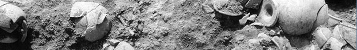
Seal impressions found in the stratum 14 store rooms attest to the administrative nature of this area and reveal how political stratification accompanied the urbanism of Tell Leilan at 2600 BC (Figure 5). These sealings indicate that Šehna elites had abandoned the abstract Piedmont style which had been popular during the early third millennium, creating a new style that combined southern Mesopotamian and Western Syrian iconography (Matthews 1997: 196-197). The most popular motif at the Acropolis Northwest, the banquet scene, borrowed from souther Mesopotamia, probably lent legitimacy to the new rulers of Šehna. The deposition of 32 vessels, including cups and other feasting equipment, in a pit next to a period IIIc elite grave at the Acropolis Northwest indicates that banquets and feasting had long played this role at Tell Leilan (Schwartz 1986, 1988) (Figure 6). The shift in iconography coincided with an increase in the scope of sealing activities (as seals were applied to containers, clay strips, and doors) that indicates expanding administrative control (Parayre 2003; Marchetti 1996).
A catastrophic fire destroyed the strata 13-14 storage rooms west of the Cultic Platform, preserving their contents (Figure 7 ). Barley was heaped up in one of these rooms. The other two rooms contained large storage jars filled with different types of grain-including barley, emmer wheat, durum wheat and emmer chaff (Wetterstrom in Weiss, et al., 2002). A long corridor separated these storage areas from a massive wall to the north, the southern wall of the Akkadian Palace. Carbonized barley seeds found in and among these containers date the end of stratum 14 and indicate how elites at Šehna stored grain surpluses for redistribution. By the end of the Leilan IIa period these storage rooms were abandoned, but this area was open space during the entire Leilan IIb occupation period.
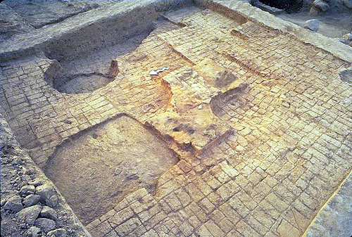 Figure 1. |
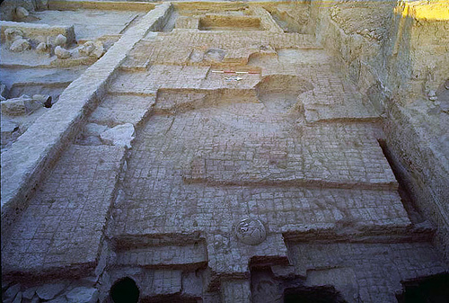 Figure 2. |
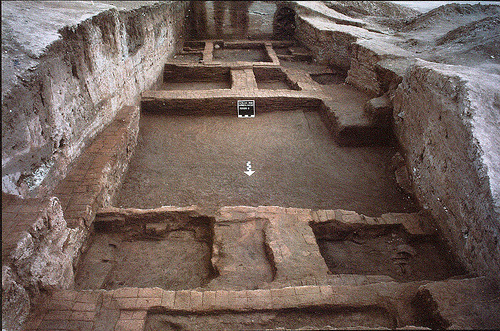 Figure 3. |
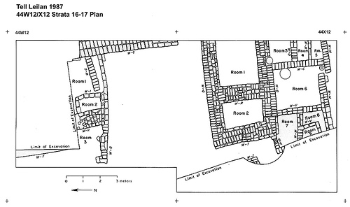 Figure 4. |
 Figure 5. |
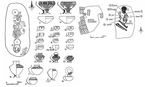 Figure 6. |
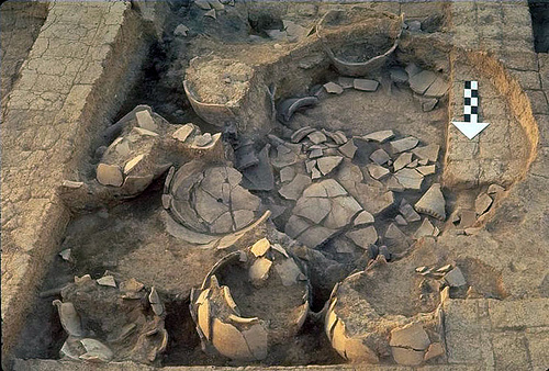 Figure 7. |
Leilan IIb: The Akkadian Conquest
Sometime after the period IIa grain storage fire, the Akkadian conquest of the Habur Plains displaced the local Šehna elites who had governed the city from the Acropolis Northwest for 300 years. Šehna’s experience under the Akkadians was not unusual, instead, the same process unfolded at Susa, Kirkuk, Erbil, Nineveh and Brak (De Lillis-Forrest, et al., 2004). Evidence for these Akkadian personnel come from sealings retrieved at the Acropolis Northwest and illustrate that an Akkadian šabra official now initiated and controlled agricultural and construction projects (Figure 8). Four construction projects at the Acropolis Northwest document this Akkadian control.
-
The Cultic Platform was renovated, its surface was covered with new, square-bricks (“reminisicent of Maništušu at Nineveh”) (De Lillis-Forrest et al. 2004).
-
New Akkadian structures were built for Akkadian administrative purposes on both sides of the east-west street that led from the Cultic Platform, including the Akkadian schoolroom, the Akkadian House, the Akkadian Palace and The Unfinished Building.
-
Massive fortifications were built on the northern and western edge of the Acropolis. These fortifications include nearly seven meter thick walls in the Akkadian Palace to the north and a glacis probably 15m high, as well as the Western Acropolis Wall.
-
A deep moat was dug along the eastern and southern edge of the Akkadian administrative complex at the Acropolis Northwest.
At the heart of the Akkadian construction project was the erection of three new buildings-The Akkadian House, The Akkadian Palace and The Unfinished Building both south and north of the Acropolis street (Figure 9). The constant renovation and rebuilding of the Akkkadian House and the Akkadian Palace suggest that they were both used for nearly a century. The Unfinished Building (TUB), however, was the final Akkadian building project undertaken at the Acropolis Northwest-and as its name indicates, its construction was abandoned before it could be finished.
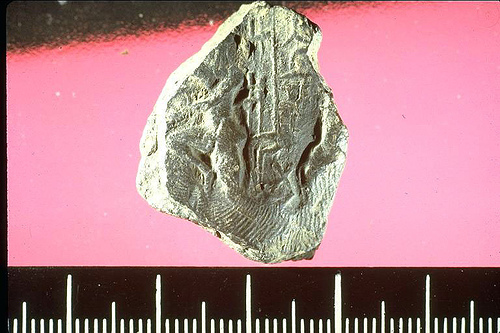 Figure 8. |
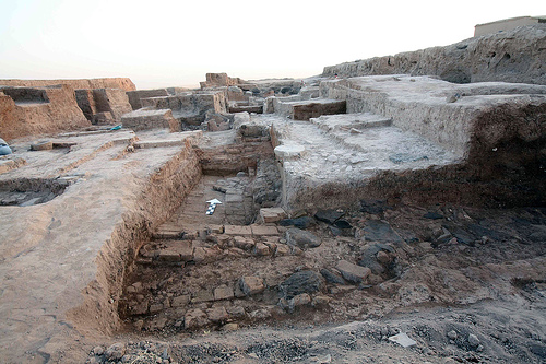 Figure 9. |
Leilan IIb: South of the Street The Schoolroom
The first Akkadian building project undertaken at the Acropolis Northwest was the construction of a schoolroom (stratum 11, period IIb3), perhaps in order to train local officials in Akkadian script and administration (Figure 10). Although most of this room was disturbed by a large modern pit, a mudbrick box in the northwest corner was undisturbed. Excavation revealed that this box contained 15 fragmentary tablets. It closely resembles baked brick boxes found in House F at Nippur’s tablet Hill, and a house in Sippar Amnanum occupied by two gala mahs. As Eleanor Robson explains “These boxes, it appears, functioned as recycling bins, into which old tablets could be thrown for soaking, reshaping, and re-using,” (Robson 2001: 44). Although a few administrative texts were present, at least four tablets are round and contain a few practice cuneiform signs in Old Akkadian script, like other school texts
(Figure 11). (De Lillis-Forrest et al. 2004).
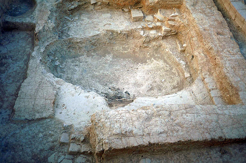 Figure 10. |
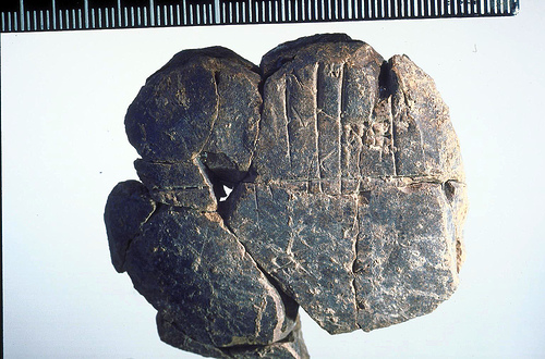 Figure 11. |
The Akkadian House
In the following period (stratum 10, period IIb2), the school room walls were leveled in order to build a 150m2 three-room building, The Akkadian House (Figure 12). Two small rooms, filled with a dense sherd packing, opened onto a large courtyard, furnished with grain bins, ovens, grinding stones, and several smashed storage jars. The original floor surface was paved with baked bricks and stones, placed over truncated IIa walls; later plaster floors were laid atop this initial surface. A 2m wide wall with basalt foundations served as the southern limit of this area
(Figure 13). This wall comprised the first stage for the construction for TUB. A well-built water drain was built so that waste flowed from the foundations of this wall into the sherd and cobble-paved street to the north (Figure 14).
The walls of this building were reused during the next phase, (stratum 9, IIb1), but in this phase, the floor surface was stamped earth, with two new baked brick pavements. Some of the earlier features were probably reused during this phase, but the earlier oven was abandoned in favor of two new ones. Seven Akkadian sealings, a tablet fragment, and 20 balls of sealing clay, were recovered from the floors and oven, indicating bureaucratic control over Akkadian House activities. During this phase, this area was used in conjunction with the construction of The Unfinished Building.
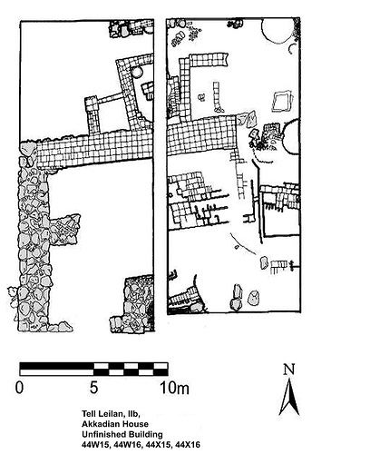 Figure 12. |
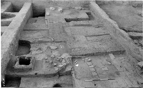 Figure 13. |
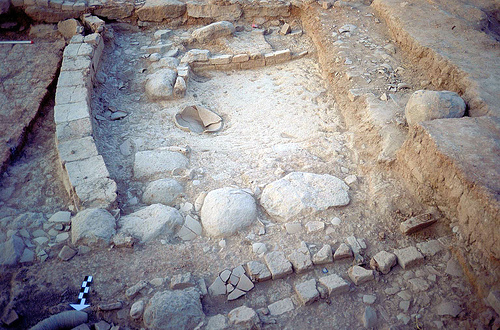 Figure 14. |
The Unfinished Building
The latest IIb phase (stratum 9, IIb1), saw the partial construction of a large building with dressed basalt foundations to the south of the Akkadian House. The basalt foundations, thick walls, large rooms, and administrative artifacts dumped onto unfinished floors (tablet fragments, studied by Lucio Milano, Università di Venezia, and punctated clay balls) suggest that this was an imperial project of large scale. TUB measured 14 meters from east to west and 9.6 meters from north to south. The Unfinished Building’s exterior walls are 1.86m thick. These walls are built out of roughly worked basalt boulders, topped with a surface of mud plaster and carefully-laid large potsherds, as well as, in some cases a few courses of red square mudbricks (Figure 15). (Weiss 1997: Fig. 25). The western wall of this building also had a few baked bricks placed between the boulders and the mudbricks to level the intended brick wall construction (Ristvet and Weiss 2000).
Several basalt boulders were found abandoned several meters from a partially built wall, laid there to form the unbuilt eastern limit of TUB. These basalt boulders were in various stages of preparation, some already worked into usable blocks, some with visible chisel marks but not yet a usable shape, and some still unworked (Figure 16). Similar boulders have also been found to the west of this building. As there are no basalt outcroppings near the site, it seems likely that the boulders were transported from the major basalt sources 40 km to the northeast.
Adjacent to the unfinished building, bordering its eastern wall, a 2.8 X 2.7m plastered foundation deposit pit was found in a period IIa leveled wall (Figure 17). This deposit contained three bronze pins, several bone, frit, and shell beads, three grinding stones, as well as nineteen whole or reconstructable period IIa vessels. The deposit at least superficially resembles those recovered from pre-Akkadian/Early Akkadian contexts at other northern Mesopotamia sites, such as Brak and Taya (Matthews 1994; Reade 1968). This wall foundation deposit, as well as the size and height of the visibly truncated period IIa walls, suggests that the massive unfinished period IIb/Akkadian building was placed atop razed, similarly massive IIa structures.
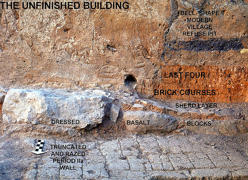 Figure 15. |
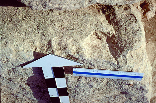 Figure 16. |
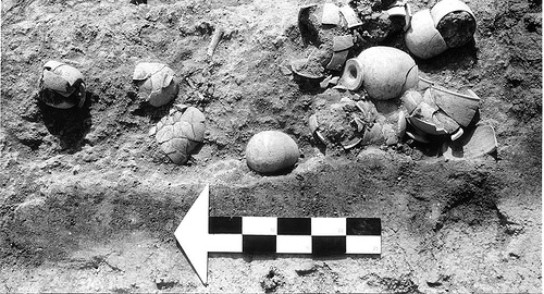 Figure 17. |
Leilan IIb: North of the Street The Akkadian Palace
North of the Acropolis street lay the Akkadian Palace, a fortified administrative building (Figure 18). Excavations in 2002 and 2006 exposed strata 8-11, the Leilan IIb and Leilan IIc phases of this palace. A sounding to the north of the IIa storage rooms (just south of the Akkadian Palace) confirms that the southern wall, like the western Acropolis wall was built in stratum 14, indicating that the Akkadian Palace was initially constructed in Leilan IIa. During the initial IIb construction, however, the walls of the IIa palace were leveled and then covered with plaster to create the IIb floors. The 1000m2 exposure of the Akkadian Palace revealed three different functional areas within this administrative building: fortifications, grain-processing facilities, and an administrative office.
In the west and north, a massive glacis, which now forms part of the northern slope of the Acropolis Tell was built against fortification walls (Figure 19). These solidly built walls were preserved to a height of up to 2m and were as much as 6.6 m thick. Four long north-south corridors pierced these fortification walls and provided access to the work areas to the south (Figure 20). The glacis itself consisted of soft, clean fill with a hard, thick crust of pisé. The thick fortification walls, use of basalt blocks, and the glacis construction most closely resembles the late third millennium building recently excavated at Tell Bazi (ancient Armi/Armanum) on the Euphrates (Otto 2006).
South and east of the glacis, lay the grain processing facilities, a series of rooms that contained multiple ovens (fourteen were recovered, although not all contemporaneous) (Figure 21). Most of these circular ovens were quite large, diameters ranging between 1 and 3m, and used intensively. Ashes from the ovens covered the floors of these workspaces, requiring them to be constantly rebuilt as the ash piled-up. When the ovens wore-out, new ones were built, often so that a larger oven surrounded an older one (Figure 22). To the west of these facilities, lay a large and deeply preserved room with baked-brick walls. Its location and construction suggests that it served as the central granary, a storage facility for the grain processed in the ovens. Three vents were built into the southern wall of the granary and an elaborate drain was attached. The intensity of the grain-processing operation here was such that a fine layer of phytoliths covered every floor of the Akkadian Palace. The great number of cereal-processing ovens at the heart of this fortified building attests the cereal agriculture base of Akkadian agro-imperialism on the Habur Plains.
East of the oven rooms, lay “the tablet room”, the office where the activities in the oven rooms were overseen
(Figure 23). A large ceramic jar, clay balls and blank tablets littered the floor of this room. A basalt grain measure, with a capacity of two liters, was also found here. Two sila, roughly two liters, was the standard daily ration of barley for a laborer in Akkadian administrative texts. It seems likely that this room was part of the bureaucratic epicenter of this Akkadian palace. The rest of the offices probably lie in the unexcavated eastern wing of the palace.
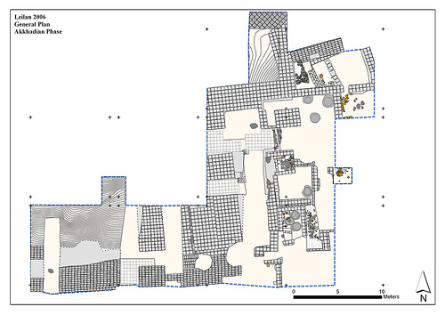 Figure 18. |
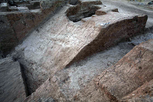 Figure 19. |
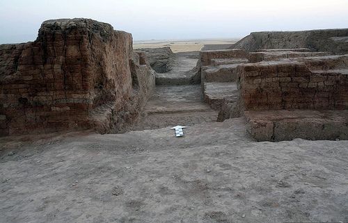 Figure 20. |
 Figure 21. |
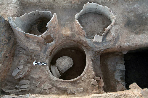 Figure 22. |
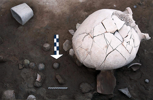 Figure 23. |
The Post-Akkadian Palace
Although at least corridors and the grain-processing facilities of the Akkadian palace were abandoned at the end of stratum 9, 100m2 of this palace was built (Ristvet, Guilderson, and Weiss 2004). These four rooms comprise the only exposure of Leilan IIIc (stratum 8), defined by its post-Akkadian ceramic assemblage, a period during which the site was abandoned (Figure 24). Twelve radiocarbon multi-aliquot barley samples were retrieved from the last post-Akkadian floor. Combining these dates to reduce their standard deviations allows us to date the final use of the floor between 2174 and 2141 BC with 95% confidence. Leilan IIc was thus short-lived at the Acropolis Northwest; by no later than 2140 BC this building lay in ruins along with the rest of Tell Leilan, a few decades after the onset of the 4.2 Ka BP abrupt climate change.
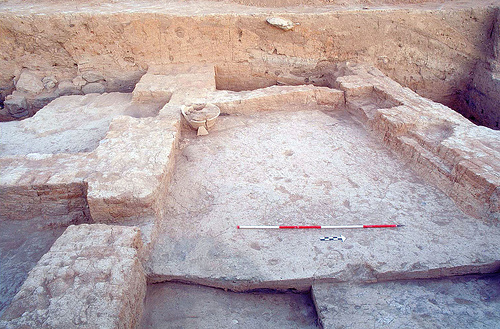 Figure 24. |
Conclusion
Excavations at the Acropolis Northwest have uncovered diverse administrative, religious and manufacturing areas, emphasizing the variety of public architecture during this period. A major goal of excavations here has been to test hypotheses about the economic foundations of state development and imperialism. Ongoing archaeobotanical and zooarchaeological analyses will add to our understanding of how local elites at Šehna harnessed high agricultural yields to maintain themselves at this city and how imperial Akkadian officials exploited this area economically. Future work at the Acropolis Northwest will investigate Akkadian imperialism by excavating the official sector in the eastern wing of the Akkadian Palace. Finally, long term work at the Acropolis Northwest seeks to uncover the pre-urban architecture of this district, in order to understand the roots of Tell Leilan’s 2600 B.C. urbanization.
Works Cited
- Calderone, Laura, and Harvey Weiss. 2003. The End of the Ninevite 5 Period at Tell Leilan. In The Origins of Northern Mesopotamian Civilization: Ninevite V Economy, Society and Culture, edited by H. Weiss and E. Rova. Turnhout: Brepols, pp.193-220.
- De Lillis-Forrest, Francesca, Lucia Mori, Thomas Guilderson, and Harvey Weiss. 2004. The Akkadian Administration on the Tell Leilan Acropolis. Poster at 4ICAANE, March 29-April 3, 2004, at Berlin.
- Marchetti, Nicolò. 1996. The Ninevite 5 Glyptic of the Khabur Region and the Chronology of the Piedmont Style Motives. Baghdader Mitteilungen 27:81-114.
- Matthews, Donald. 1997. The Early Glyptic of Tell Brak: Cylinder Seals of Third Millennium Syria. Vol. 15, Orbis Biblicus et Orientalis. Series Archaeologica. Freiburg: University Press.
- Otto, Adelheid. 2006. Archaeological Perspectives on the Localization of Naram-Sin’s Armanum. Journal of Cuneiform Studies 58:1-26.
- Parayre, Dominique. 2003. The Ninevite 5 Sequence of Glyptic at Tell Leilan. In The Origins of North Mesopotamian Civilization: Ninevite 5 Chronology, Economy, Society, edited by H. Weiss and E. Rova. Turnhout: Brepols, pp.271-310.
- Ristvet, Lauren. 2005. Settlement, Economy and Society in the Tell Leilan Region, Syria, 3000-1000 BC, University of Cambridge, Cambridge.
- Ristvet, Lauren, Thomas Guilderson, and Harvey Weiss. 2004. The Dynamics of State Development and Imperialization at Third Millennium Tell Leilan, Syria. Orient-Express 8.
- Ristvet, Lauren, and Harvey Weiss. 2000. Imperial Responses to Environmental Dynamics at Late Third Millennium Tell Leilan. Orient-Express 4:94-99.
- Robson, Eleanor. 2001. The Tablet House: A Scribal School in Old Babylonian Nippur. Revue Assyriologique 95 (1):39-66.
- Schwartz, G. M. 1986. Mortuary Evidence and Social Stratification in the Ninevite V Period. In The Origins of Cities in Dry-Farming Syria and Mesopotamia in the Third Millenium BC, edited by H. Weiss. Guilford: Four Quarters Publishing, pp.45-60.
- ——. 1988. A Ceramic Chronology from Tell Leilan, Operation 1. Edited by H. Weiss. Vol. 1, Yale Tell Leilan Research. New Haven: Yale University Press.
- Weiss, H. 1990. Third Millennium Urbanization: A Perspective from Tell Leilan. In Tell al-Hamidiya 2, edited by S. Eichler and M. Wäfler. Fribourg: Universitätsverlag Freiburg, pp.159-166.
- Weiss, Harvey. 1990. “Civilizing” the Habur Plains: Mid-Third Millenium State Formation at Tell Leilan. InResurrecting the Past, edited by P. Matthiae, M. Van Loon and H. Weiss. Leiden: Nederlands Historisch-Archaeologisch Insitut voor het Nabie Oosten,
- ——. 1997. Leilan. In Archaeology in Syria, edited by H. Weiss, pp.126-129.
- ——. 2003. Ninevite 5: Periods and Processes. In The Origins of Northern Mesopotamian Civilization: Ninevite V Economy, Society and Culture, edited by H. Weiss and E. Rova. Turnhout: Brepols, pp.593-624.
- Weiss, Harvey, Marie-Agnes Courty, Wendy Wetterstrom, F. Guichard, Louise Senior, Richard Meadow, and Anne Curnow. 1993. The Genesis and Collapse of Third Millennium North Mesopotamian Civilization. Science261:995-1004.
- Weiss, Harvey, Francesca deLillis, Dominique deMoulins, Jesper Eidem, Thomas Guilderson, Ulla Kasten, Torben Larsen, Lucia Mori, Lauren Ristvet, Elena Rova, and Wilma Wetterstrom. 2002. Revising the Contours of History at Tell Leilan. Annales Areliéolopiques Arabes Syriennes Cinquentenaire.