About the Project
ArchaeoSim was an HTML5 simulation for exploring social and natural dynamics of Third Millennium BC Subir (northern Mesopotamia). Harvey Weiss and Ginger Booth (2005-2014).
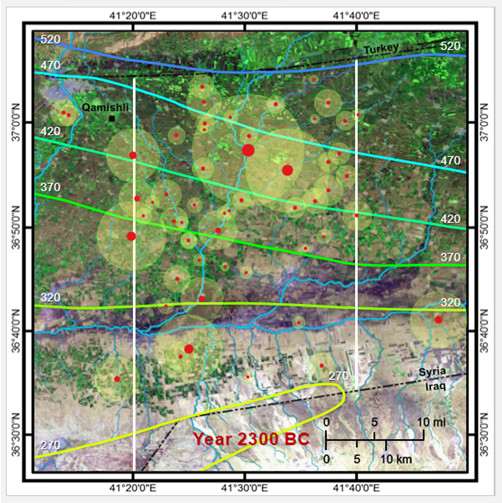
ArchaeoSim simulated the population and agricultural dynamics of ancient Subir, the dry-farming region of northern Mesopotamia, from 2600 to 1728 BC. The simulation modeled farm area, grain yields, population growth and immigration, grain stores, some migration of non-farm labor from smaller sites to larger, and a simple model of agricultural surplus production. The data driving ArchaeoSim was a high resolution archaeological survey of the Leilan survey region, a 30 km transect of 1900 sq kms in NE Syria, spanning the Khabur triangle from the Turkish to the Iraqi borders, giving settlement sizes and locations. ArchaeoSim also used paleoclimate data for rainfall levels.
Background
IIb - Akkadian Imperialization
Survey data underwent major revision, from 509 occupied hectares, down to 353 (down 44 percent). And qualitatively, this period is now understood to have a lower population than the preceding period, instead of continued growth. So despite increased rainfall, this scenario’s population now falls slightly, again via a negative immigration value. Perhaps the Akkadians displaced some of the labor force.