
Ottoman Decline
Multiple travelers’ records during the 18th and 19th centuries describe the fertile Assyr- ian and Khabur Plains as strangely devoid of villages and agriculture, empty plains only traversed by mobile pastoralist tribes (e.g., Ainsworth 1842). These observations have been buttressed by Ot- toman archival research within earlier 16th century defter-s that record agricultural taxation down to the village level, and across impressively occupied imperial border regions onto the Khabur Plains (Göyünç/Hütteroth 1997). The travelers’ accounts and tax records have fueled the historiographic debate about late Ottoman decline, poor imperial administration, and the loss of the countryside to plundering tribes who made sedentary agriculture difficult (Hütteroth 2006). Gertrude Bell described, however, the effects of the early Berlin to Baghdad railway links to the west, from Nusaibin to Aleppo: investor excitement at the prospect of cereal harvest rail transport to the now-capitalized markets of western Syria (Bell 1917:134). Thereafter, agricultural production, and settlement, quickly began to flourish on the Khabur Plains (Velud 1987). By 1920 the new French administration extended the rail line to only five kilometers north of Tell Leilan, with a picturesque French railroad station of post-and-beam timbers, mansard roof, and a doorway signed in French and Arabic (Fig. 10). To this day, the region’s cereal harvests are collected here and then transported west by rail. What drove the earlier settlement and cereal agriculture decline? Were the new rail transport, administrative control, and market orientation the keys to rejuvenated Khabur Plains cereal production? The Leilan Region Survey documents the expansion of settlement in the tenth through fourteenth centuries and rapid decline beginning in the sixteenth century and extending through the nineteenth century (Vezzoli 2008). Geoarchaeological sampling along the wadi Jarrah in 2002 produced stratified sediment samples that were subsequently analyzed for pollen-based natural veg- etation changes and radiocarbon dating (Besonen/Cremaschi 2002). Conjoining the Ottoman tax records, the Leilan Region survey data, and the radiocarbon-dated pollen-based natural vegetation changes, we discern the dynamic environmental background for the past four hundred years’ successive settlement expansion, decline, and expansion. With the onset of the Little Ice Age in the sixteenth century, Khabur Plains climate became cooler, drier, and less favorable for dry-farming cereal agriculture. Only at the end of the nineteenth century did conditions favorable for cereal agriculture return, an opportunity for resettlement and expanded dry-farming coincident with the French rail transport linkages that made cereal export profitable (Kaniewski/Van Campo/Weiss 2012). Still effective today, the French railroad station, with its dressed basalt block footing, is reminiscent of an earlier regional intrusion, and the dynamic Khabur Plains environments within which social forces have been both promoted and constrained over the past five millennia.
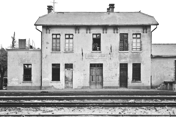
Fig. 10 French railroad station, “Kubur el-Bid,” constructed 1920, five kilometers north of Tell Leilan, for regional cereal harvest transport to Aleppo; H.Weiss photograph, 1991.