Introduction
Three seasons of excavations at Tell Leilan-Operation 4 (1985), Operation 4 Extension (1991) and Operation CG (2002)-have explored the construction of the Leilan City Wall and the use of space at the edge of the city (Fig. 1). Between 2600 BC, when the first fortifications were built, and 1700 BC, when the city was abandoned, Tell Leilan underwent a series of transformations-including urbanization, imperialization, abandonment, and resettlement. Excavations at the City Wall has helped to quantify all of these processes. The excavations provide new evidence for the growth of administrative control at the dawn of urbanism in this third millennium urban center, the Akkadian imperial reorganization of this city, and the second millennium transformation of this city into Šamši-Adad’s capital city. They also shed light on domestic life and burial practices in the third and second millennium.
The Leilan City Wall rises five to fifteen meters above the surrounding plain and generally spans twenty to thirty meters. Two areas of the City Wall have been systematically investigated. Operation 4 and the Operation 4 Extension were soundings through the City Wall at a natural depression along its northeastern side (Fig. 2). They were excavated mechanically and by hand down to virgin soil. Op. CG was set alongside the natural depression which marks the main northern entrance to the city. Bulldozer damage here meant that we could investigate the entire 30+ meter section of the northern City Wall. Excavation has revealed that the City Wall mound was not built at one time, but that it is comprised of a complicated series of mudbrick and pisé walls which were built and rebuilt from 2600 BC to 1700 BC. Adjacent to the City Wall, excavation has uncovered an administrative area at the City Gate dating from 2600-2400 BC (Leilan IIId/IIa), a defensive installation at the City Gate dating from 2400-2200 BC (Leilan IIa/IIb), and private houses and burials from 2300-2200 and 1900-1700 BC (Leilan IIb/I).
 Figure 1. |
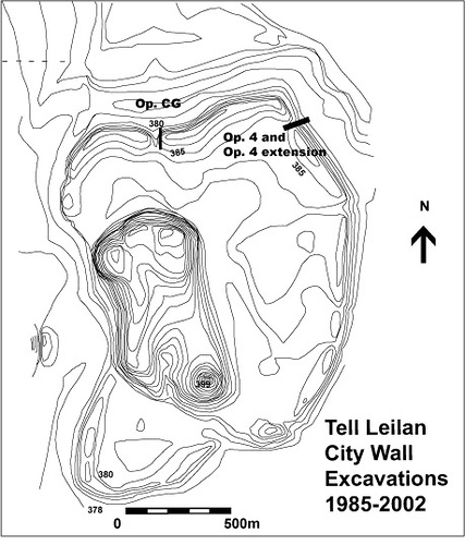 Figure 2. |
The Construction History of the City Wall
Leilan IIId-IIa: The CG sounding exposed the earliest fortification wall of any of the City Wall excavations, indicating that these fortifications were built at 2600 BC (Leilan IIId), coincident with the urbanization of Tell Leilan (Fig. 3). The first stage of this fortification system was characterized by the construction of a set of earthworks. This initial construction took advantage of a natural rise and depression to the north of the city. A 10 m wide and 10 m deep ditch was created to widen and deepen the natural depression and two artificial mounds were constructed by mounding this virgin soil on the natural rise. These earthworks were originally at least 10m thick and 3m high. Wall A-a massive mudbrick fortification wall for the city and its gate complex-was cut into these mounds, so that they served as a glacis in front of this wall. Wall A was a minimum of 3m wide and is preserved to a minimum height of 2.5m. It was constructed of alternating red and black bricks, made from the calcic horizon plain soil and the black mud of the Wadi Jarrah respectively. The construction of this wall was dated to 2600 BC on the basis of late excised Ninevite 5 pottery found on the earliest floor adjacent to this wall and radiocarbon samples taken from burnt seeds found on this floor in Op. CG.
Leilan IIb: At approximately 2300 BC, during the Leilan IIb period, the City Wall fortifications were greatly enlarged. Fortifications dating to this period were discovered both at the Northern City Gate and in the Operation 4 extension, indicating a slightly different construction history in these two quarters. Excavations in the Op. 4 extension revealed two walls, each 8 meters wide, with a 1 meter wide middle wall-perhaps a walkway-running between them (Weiss et al. 1993: 999). At Op. CG, the space between these two walls was widened to accommodate the administrative quarter situated here. Another wall (1 m wide) was built just to the south of Wall A, the northern City Wall, with at least one buttress, to strengthen the fortifications here. 9 meters to the south, a second, middle wall (1 m wide) was placed. Finally, 15 meters south of this, a final wall (3m wide) delimited the southern end of the City Gate district. As a result of this enlargement, the third millennium city gate area was more than 30 meters wide.
Leilan I: Second millennium fortification walls were recovered in both City Wall soundings. In Operation 4, which investigated the eastern City Wall, eight courses of a second millennium fortification wall was built atop earlier second millennium houses. This wall was constructed of dark-red bricks that are identical to those used to build the Acropolis Northeast Temple. This wall was approximately 15 m wide. It seems likely that Šamši-Adad built the second millennium City Wall as part of the same building project that created the Acropolis Northeast Temple and the Eastern Lower Town Palace. In Op. CG, along the Northern City Wall, no second millennium wall was uncovered, but a set of earthworks, which literally covered all of the third millennium deposits, was created to fortify this area.
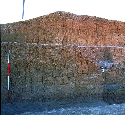 Figure 3. |
Along the City Wall: The Gate House, Cemeteries, and Private Dwellings
Op. 4 and Op. CG also investigated how people used the space adjacent to the City Wall. On one hand, Op. CG provides evidence for the public nature of the City Gate precinct, through the excavation of multiple phases of administrative quarters here and the discovery of the (IIa) Northern road that entered Tell Leilan (McCarthy and Ristvet 2009). On the other hand Operation 4 provides evidence for second and third millennium domestic spaces.
In Op. CG, the space south of Wall A during phases 1-5 (IIId-IIa) and between the northern and southern fortification walls in phases 6 and 7, were divided by small pisé and mudbrick walls into a variety of non-domestic spaces. A series of fire-installations, some of which may have contained signaling fires, were built adjacent to the northern City Wall. The deposits in this area differ greatly from domestic deposits elsewhere at Tell Leilan. Only a very limited repertoire of ceramics was used in the IIId and IIa phases at the city gate, with three different vessel forms accounting for the vast majority of all sherds. Almost no animal bones or other domestic refuse was found here, despite the thick ash deposits which were related to the fire-installations. In contrast, sealings and other administrative devices were found in each building level dating to the third millennium at Op. CG (phases 1-7). They testify to the administrative nature of this precinct during the course of this millennium (Ristvet 2007).
In Op. 4, the oldest non-fortification architecture recovered was a two-roomed building-probably a house-dating to Leilan IIb. Unlike other houses found at Tell Leilan, the floor of this building was below ground level. Before construction, a trench was dug .3-1 m into the virgin soil south of the IIb fortification wall, and the walls of the building were then placed in this depression. Another unusual feature of this IIb building is the presence of two niches in one of the rooms; no other house at Leilan has such niches. It is possible that this unusual subterranean building was not a simple house, but no artifacts were found in situ on the floor to prove otherwise (Fig. 4). West of this building, a rectangular pit contained four burials of three adults and one infant was found. These burials were not contemporaneous, rather the pit was reopened and successive bodies were added to the original burial. Grave offerings of ceramic vessels, drinking tubes, bronze pins, and in one case a cylinder seal and a frit bead necklace were placed beside the skeletons. West of this burial pit lay the remains of another semi-subterranean building.
Excavations in Operation 4 also uncovered the only second millennium domestic architecture found at Tell Leilan. Three second millennium phases were recovered here. The earliest phase saw densely packed houses extending across most of the Op. 4 sounding (Stein 1990: 554). At least eight packed earth floors with domestic refuse indicates that this was a long-lived domestic area. During the middle phase, these houses were abandoned and this became an outdoor space, although the amount of domestic refuse suggests that it was located near a domestic area. The final phase in this area witnessed the construction and use of the second millennium BC City Wall. At the base of the City Wall, a pipe and a sump pit were constructed to serve as a dump for trash and sewage. Outside the wall, a pit containing two burials was dug through the earlier Period I house floors. A layer of flat mudbricks covered the burials while a brick wall ran along the northern edge of the burial pit. Burial 5, the richer of the two burials contained an unusual oil lamp in the form of an andiron with incised and punctuated geometric decorations, several vessels, and the skeleton of a dog lying between these jars (Fig. 5).
 Figure 4. |
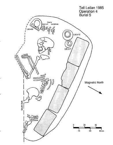 Figure 5. |
The City Wall and Urban Space at Tell Leilan
The dimensions of the ancient City Wall have made the excavation of this area quite complex, however these three soundings have revealed much about the nature of these fortifications and the use of this area during both the third and second millennium BC. At all periods the City Wall district had a unique character; and the buildings and deposits associated with it differ dramatically from those in other areas of the ancient city.
The construction of the City Wall during the mid-third millennium, coincident with the construction of the 75-hectare lower town at Leilan, emphasizes the urban-planning which accompanied the rise of this city. The City Wall complex, with its wide walls built of contrasting bricks, reflects the carefully laid streets and planned neighbourhoods of the lower town (Weiss 1990, 1990; Ristvet 2007). The construction of the City Wall practically and symbolically highlighted Leilan’s new dominant role on the Eastern Habur plains. Scholars generally focus on the defensive nature of fortifications and their military use, but the Leilan excavations emphasize that their role as control points, which mediated Tell Leilan’s relationship with the outside world, was as important in the daily operation of archaic states. Although the Op. CG excavation did not reveal an actual gate construction, which has probably been destroyed by road construction in this area, it did document the administrative use of this area (Fig. 6). In fact, the Op. CG excavation is the only excavation of Northern Mesopotamian third millennium fortifications that has provided evidence for the administrative use of these fortifications, which adds new complexity to our understanding of third millennium polities.
The massive City Wall extension project that occurred during Leilan IIb, when the fortifications more than tripled in size, also indicates the importance that the Akkadian empire placed on the control of conquered populations. The IIb city gate construction finds a parallel in the recent excavation of the glacis and defensive walls at the Acropolis NW Dudu Palace. Both monumental constructions served to reinforce imperial power.
Otherwise, the nature of the Leilan IIb domestic constructions along the northeastern City Wall in Op. 4 remains enigmatic. Such semi-subterranean houses do not occur elsewhere in Leilan and or not reported from other Northern Mesopotamian sites during this period. The absence of deposits associated with the floors of these buildings make it difficult to determine their function. However, the burial pit recovered in this area reveals that, as at Beydar, the area adjacent to the City Wall was used as a cemetery area-where burial pits were reused for multiple adult and infant burials (Bluard et al. 1997). Perhaps the closest Mesopotamian parallel to these buildings are the semi-subterranean houses that were used as offering places for late third millennium tombs at Ur (Reichel 2001). Of course, burials often occur near or within houses during this period as well, as is documented at the Lower Town South.
Finally, the period I excavations revealed a long-lived domestic area-the only area of the site that belongs to a Period I settlement that may predate Šamši-Adad’s building projects. These are the only Period I domestic structures which have been excavated at Tell Leilan, which suggests that private houses occupied little of the second millennium city. The evidence for limited domestic structures at Leilan shows that this site, like Rimah (Qattara) and Mari, was a “hollow city” (Weiss 1983)-a disembedded second millennium capital, similar to those known from other areas of Western Asia.
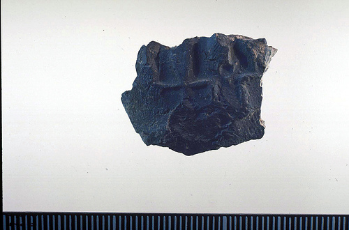 Figure 6. |
Works Cited
- Bluard, Christine, Xavier Luffin, Hannah Qoueider, and Yves Roberts. 1997. Recherches sur le périmètre externe (chantier H). In Tell Beydar, Three Seasons of Excavations (1992-1994): A Preliminary Report, M. Lebeau and A. Suleiman, eds. Turnhout: Brepols, pp.179-191.
- McCarthy, Andrew, and Lauren Ristvet, 2009. Tell Leilan: Excavations at the City Gate. H. Weiss, ed., Yale Tell Leilan Research 3. New Haven: Yale University Press.
- Reichel, Clemens. 2001. Political Changes and Cultural Continuity in the Palace of the Rulers of Eshnunna (Tell Asmar) from the Ur III Period to the Isin-Larsa Period (ca. 2070-1850 BC), Department of Near Eastern Languages and Civilizations, University of Chicago, Chicago.
- Ristvet, Lauren. 2007. The Third Millennium City Wall at Tell Leilan, Syria: Identity, Authority, and Urbanism. InPower and Architecture: Monumental Public Architecture in the Bronze Age Near East and Aegean, edited by J. Bretschneider, J. Driessen and K. Van Lerberghe. Leuven: Peeters, pp.183-212.
- Stein, G. J. 1990. Excavations at Operation 4, the City Wall Mound. In 1985 Excavations at Tell Leilan Syria, edited by H. Weiss, pp.547-555.
- Weiss, Harvey. 1983. Tell Leilan in the Third and Second Millennia BC. Annales Archéologiques Arabes Syriennes33 (1):47-73.
- ——. 1990. “Civilizing” the Habur Plains: Mid-Third Millenium State Formation at Tell Leilan. In Resurrecting the Past, edited by P. Matthiae, M. Van Loon and H. Weiss. Leiden: Nederlands Historisch-Archaeologisch Insitut voor het Nabie Oosten.
- ——. 1990. Tell Leilan 1989: New Data for Mid-Third Millennium Urbanization and State Formation. Mitteilungen des Deutschen Orient-Gesellschaft 122.
- Weiss, Harvey, Marie-Agnes Courty, Wendy Wetterstrom, F. Guichard, Louise Senior, Richard Meadow, and Anne Curnow. 1993. The Genesis and Collapse of Third Millennium North Mesopotamian Civilization. Science261:995-1004.